
Eight days after returning from San Marino and Monaco, it was already time to head to another microstate: Malta!
I’d found great rates for a rental car and Airbnb, so I’d be spending 3 days there. A lot of this challenge is go-go-go, so I wanted to find a way to mix in a bit of relaxation. It turned out that there’s so much to see in this little Island, and ‘relaxation’ isn’t really the way the plans went. (:
The most relaxing part was probably pre-airport. I flew out of Southend for the first time, parking in an affordable JustPark spot just a 10-minute walk from the terminal. The sunrise was beautiful, and a pair of horses and I spooked each other on the walk (footage in Instagram highlights).
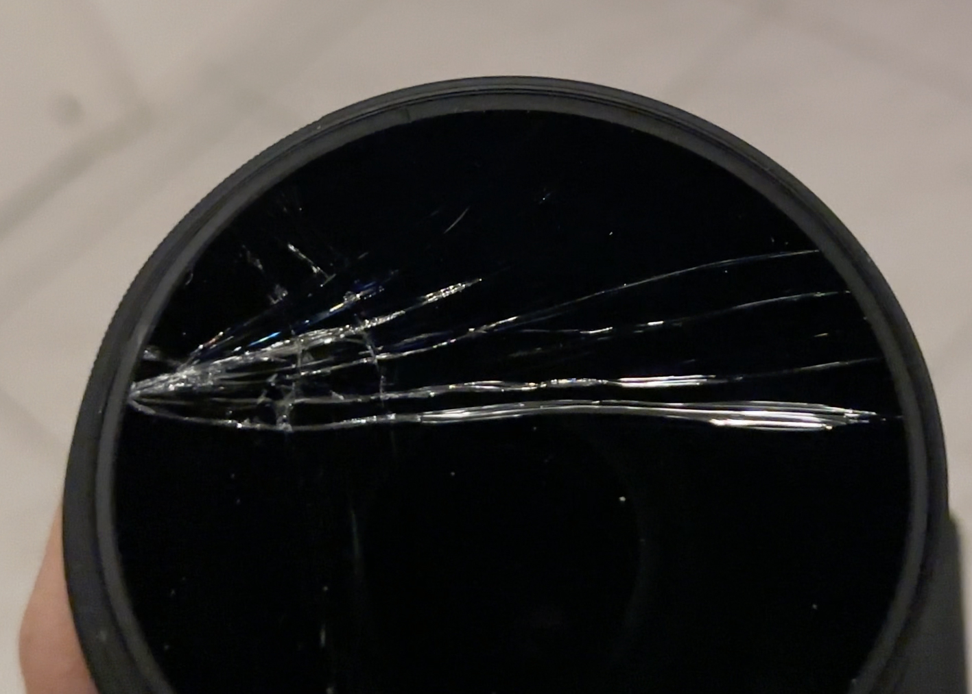
The first stroke of bad luck happened when I dropped my camera (inside the case, but it’s an ultralight case and apparently not very effective). The circular polarizer on it cracked, but the lens under it seemed unscathed! I’d just need to twist off the filter and throw it out, then carefully clean the glass. Unfortunately, this was the second time it happened with this case. The first was in Iceland, with just a regular filter on it (not even a drop, it was in my backpack. Needless to say, I’ll no longer be using this case).
This time, though, the filter wouldn’t budge. I carefully placed the camera back into the case, then looked for repair shops in Malta while waiting to board the flight. There seemed to be one on the whole island, run by one man: David Bland. It was Sunday, and they wouldn’t be open until 10am on Monday. I expected to need to work a bit on Monday and Tuesday (NYC-based hours), so this would cut into the Monday plans a bit. That basically translated into not having time for Gozo this trip. Oh well, an excuse to come back! (:
My Airbnb host, Jelena, had recommended some things to do on my first day, as I’d be picking up the car by the airport (the southeast part of the island) and staying in St. Paul’s Bay (the northwest part of the island). In the southeast, one of the most popular attractions is the Blue Grotto. The drive from the airport took maybe 10 minutes, but the queue for parking took three times that. With the crowds, I was surprised to find the boat tours closed (due to rough conditions). What was everyone doing there? There were a few hotels and restaurants, but I wondered how crazy it would be on a summer Saturday with tours running. Malta is definitely a place to visit in the shoulder seasons (April/May or October/November).
The next stop on my host’s recommended list was the Ħaġar Qim and Mnajdra Archaeological Park, which turned out to be just 5 minutes up the road. Wondering what that double-lined H is and the dot over the g? They’re letters in Maltese, the official language of Malta (along with English, mostly due to its status as a British colony until it gained independence in 1964), is the only Semitic language written using a (modified) Latin alphabet. It sounds a bit like Arabic, as it developed from a dialect of it, with Sicilian, Italian, and English influences.
Anyway, when you arrive at the park, there is free parking, and you can head into the museum to purchase entry tickets. These will be checked before each megalithic temple complex’s entrance. You can spend a bit of time in the indoor portion of the museum, but it’s pretty small. Then, it’s time to head to the first complex, the Ħaġar Qim temples.
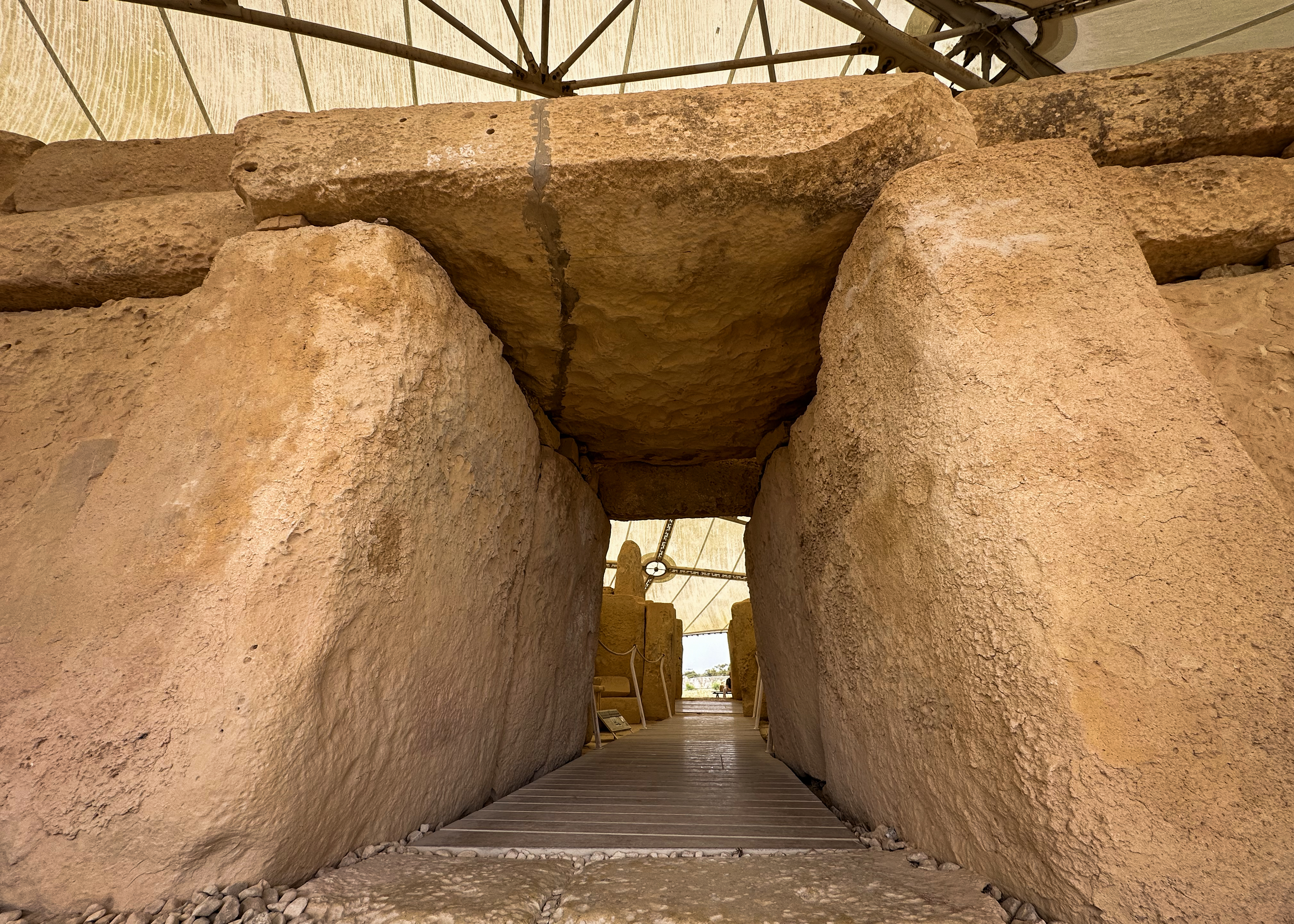
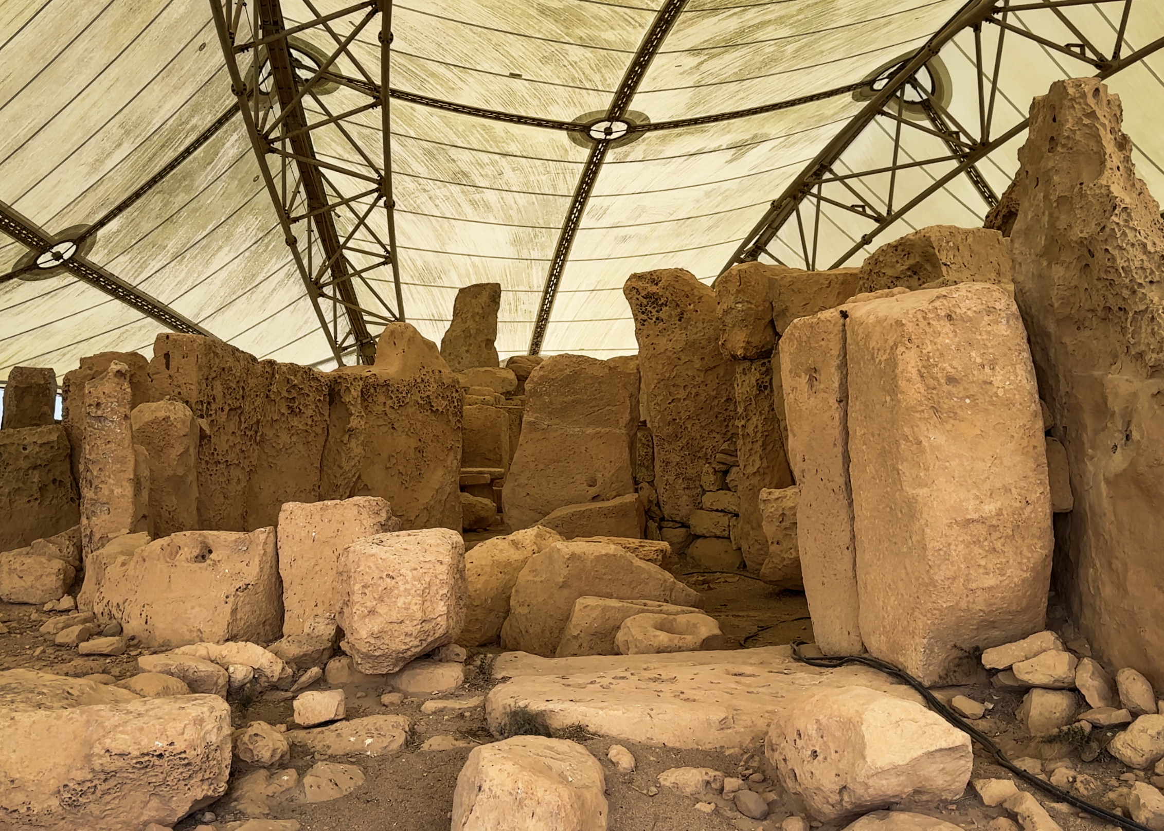
Both temple complexes had protective structures installed above them in 2008, as they were beginning to deteriorate quickly after their excavation that began in 1839. Before that, they were essentially buried under rubble, soil, and vegetation, particularly the South Temple of the Mnajdra. Those coverings protected them from fully deteriorating over their 5,000+-year existence. They were likely used for over 1,000 years by a neolithic society. That period from 4,100 to 2,500 BCE was known as the Temple period, which was followed by the Bronze Age until 700 BCE. While the Temple period started in 4,100 BCE, the first 500 years of it consisted of a transition from early farming communities. The earliest temples on the main island of Malta are these, and there’s another equally old on Gozo, the Ġgantija. The Tarxien temples came a few hundred years later. It’s apparently a mystery as to why the use of these temples stopped and architectural/cultural practices shifted completely, but it could have been related to environmental factors (not too many natural resources on this riverless, lakeless island) or population replacement (but seemingly not from war, as there is no evidence of mass graves or other signs of war).
The Mnajdra temples are just a short walk past Ħaġar Qim.
The website has a full virtual tour, if you can’t make it out there and are interested in checking it out some more! Entry prices are listed there, as well.
After Mnajdra, I saw a woman follow a side path that went along the cliffs, rather than returning back along the path toward Ħaġar Qim. I don’t think I would have noticed it if not for her…so thank you, stranger! There was a point where the path went pretty close to the edge, and I could see a stone arch in the distance.
There did seem to be a way down. Not necessarily a path…but solid rock and little clearings, with no barriers or signs. I couldn’t tell if it would get me all the way down, and I was in sandals (but good ones – Teva to the rescue, as always!), so I decided to walk as far as I could safely go. That turned out to be all the way down to a dirt path along the lowest level of cliffs. It was surprisingly hard to figure out where the stone arch was, but in my search for it, I wandered further down to these views:
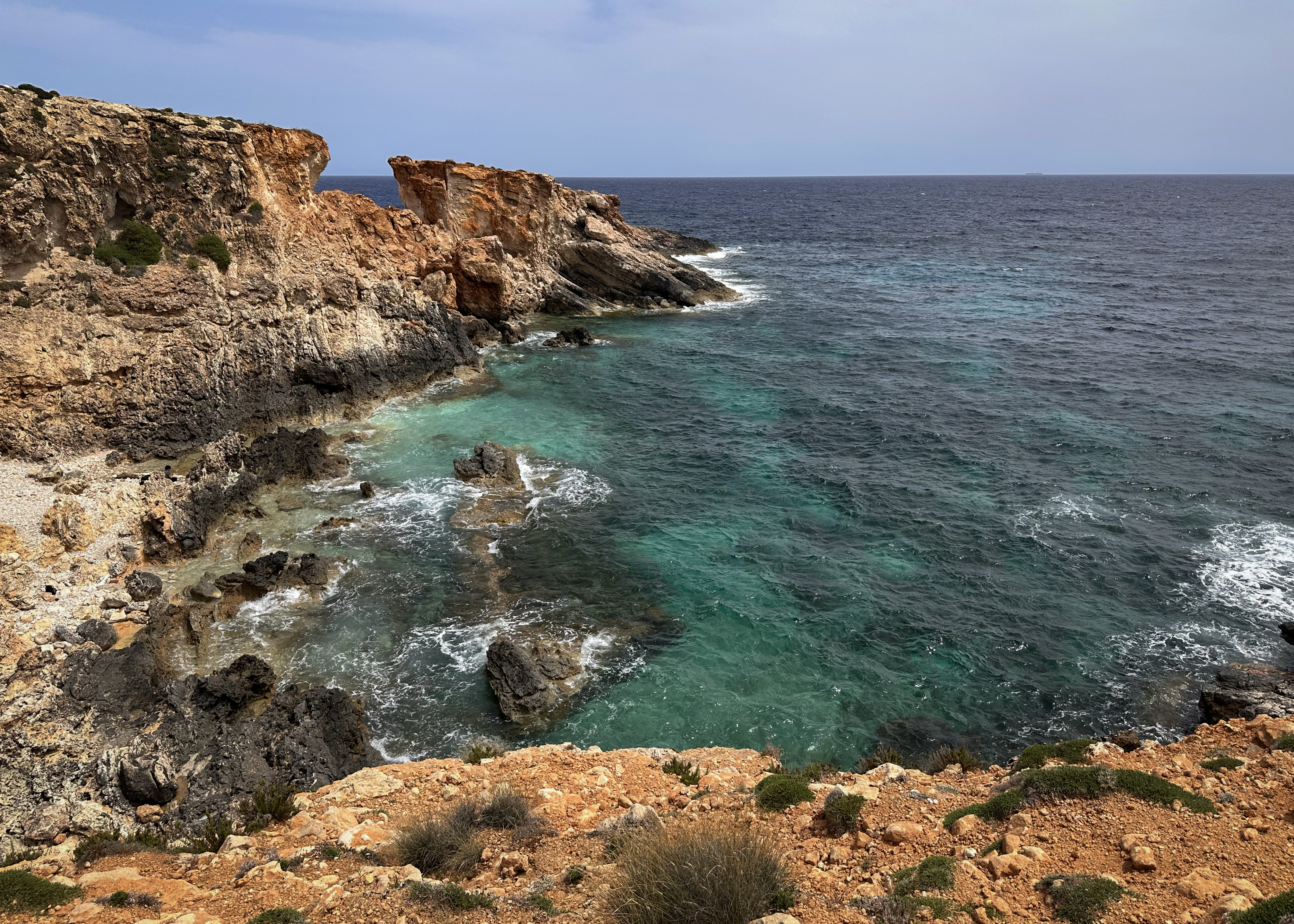
I was no longer disappointed about not seeing the Blue Grotto. There was no one here, and it was stunning! I later realized that this was a spot I’d bookmarked, Għar Ħanex (I think this is technically the name of the arch, the Għar Ħanex window)…I just hadn’t realized it was accessible right from the temples. I also didn’t realize you could follow these cliffs all the way to the highest point of Malta, along the Dingli Cliffs! Natasha Bergen did just this (but started even further out, from Żurrieq, near the Blue Grotto), so feel free to check out her YouTube video to see what that looked like!
After exploring that area a bit more, I started looking up places to eat. There was a restaurant with a pretty extensive gluten-free menu right in the Blue Grotto area I’d just come from: Aalto. Thankfully, there was no queue this time, and I found parking without too much hassle. The restaurant had seating on two floors, with sea views from the upper one. There was a table right by the balcony. I’d really recommend this spot – it’s a bit pricey, but the seafood was amazing! There are some videos of the views in the Instagram highlights.
After dinner, I drove over to the Airbnb to check in. On the way, I saw a beautiful city perched on a hill, and I took a quick screenshot of Google Maps to have a look later. It turned out to be the pretty well-known Mdina. I’d definitely be heading back there!
At the Airbnb, I met the host, who turned out to be the best host I’ve had. She had plenty of stories and a beautiful apartment, decorated with her art (she’s a painter and formerly did more photography). Given the photography background, she was empathetic to the lens situation. She also suggested checking if the cracks would make any cool effects, and they kind of did!
The next morning, I rose early to fly the drone over Mdina. After passing by the previous day, I knew it would look like a dream in early morning lighting. I thought 7am would be early enough. There was so much traffic though!! I did another Googling of Malta’s drone laws, and I found conflicting information about flying over Mdina. In any case, it felt a bit too crowded already, so I opted not to. But…I was already there, so why not head in and have a look around?
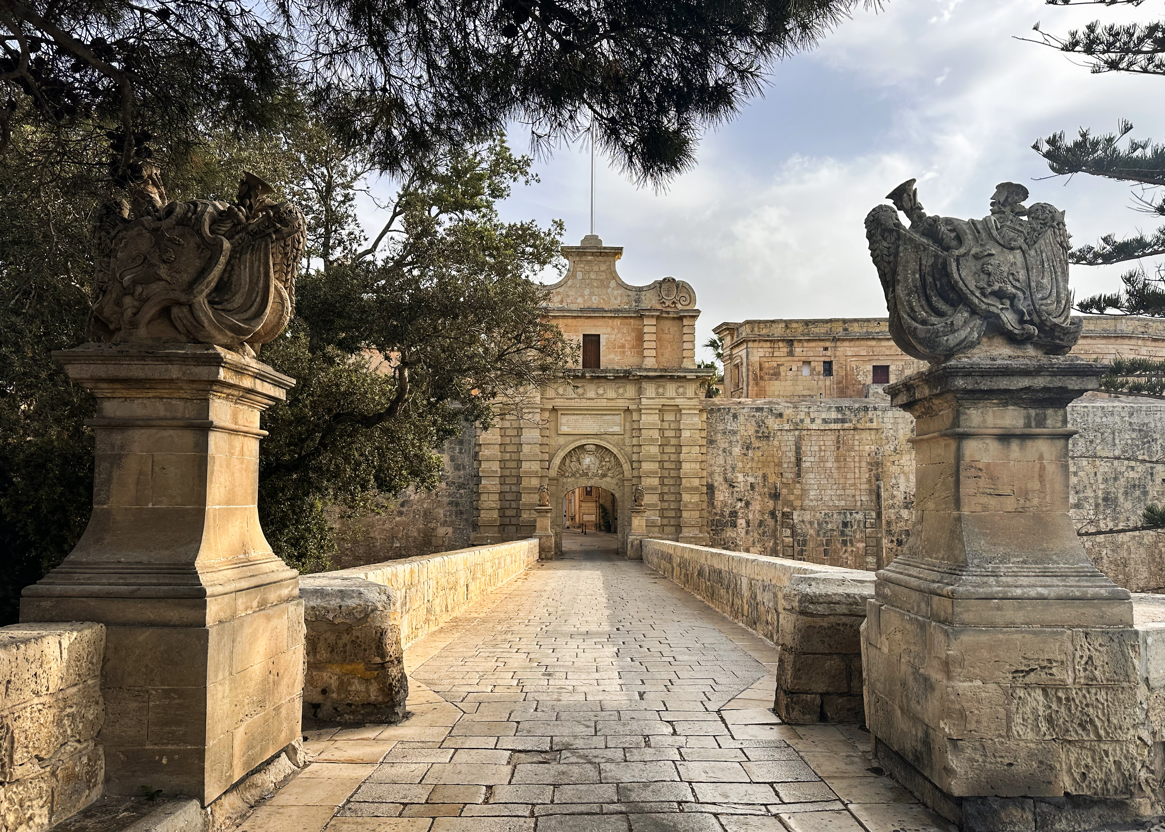
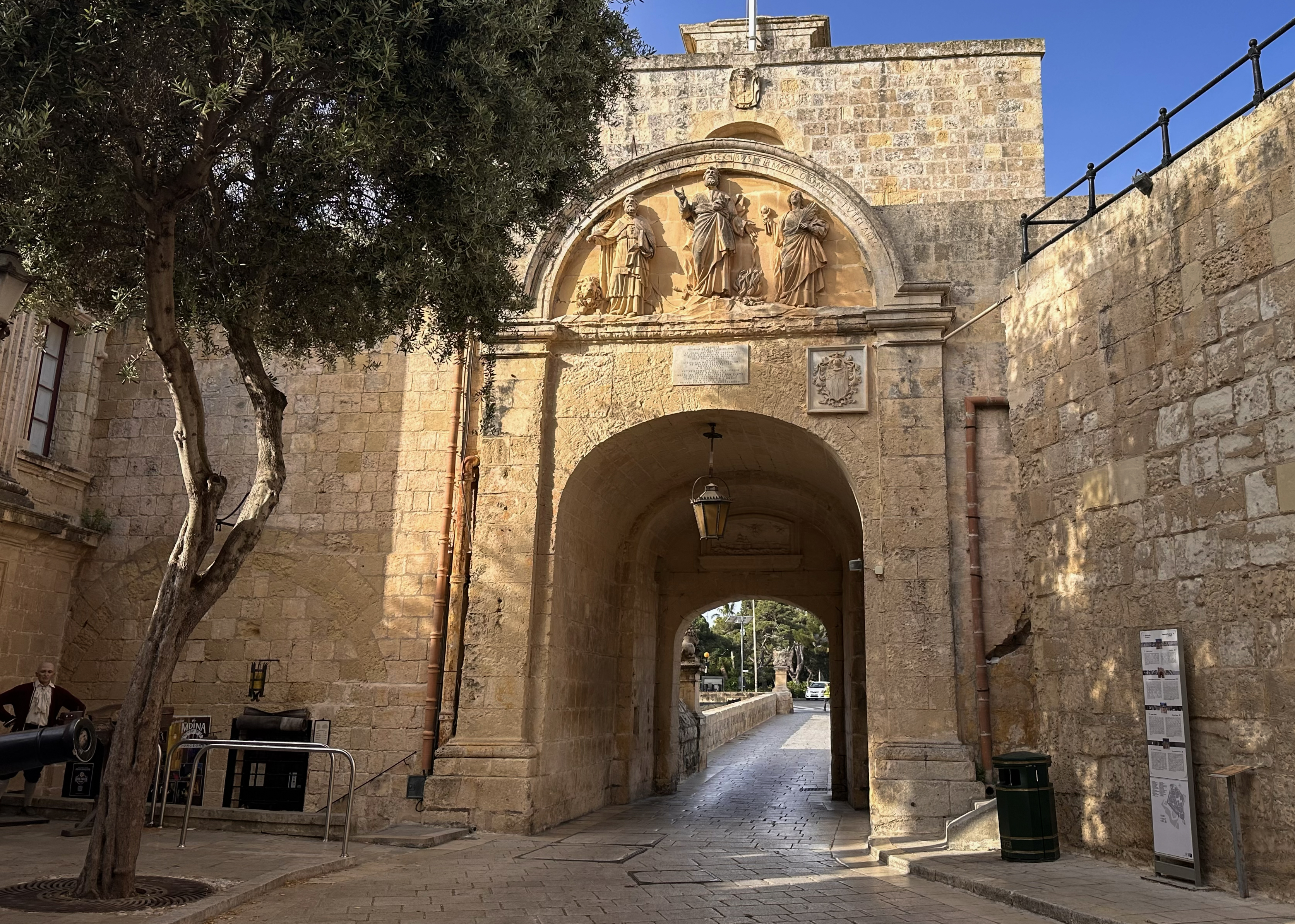
This turned out to be a perfect decision. Mdina is pretty touristy these days- maybe not as crowded as Valletta, but close. Before 8am on a Monday, there were barely any people there, just a few locals getting their restaurants and shops ready for the day. The traffic was probably from commuters, as it was a weekday, not from tourists wandering around historic sites.

There was one person I kept running into around the city. He stood out with a neon vest and a large 360 camera. Google Maps had last been updated 6-11 years ago, based on some Street View snooping. Apparently, it takes a few months to a year for new footage to be official. If that’s what he was there for…expect to see a lot of lovely, empty roads, then probably me doing something embarrassing in the background.
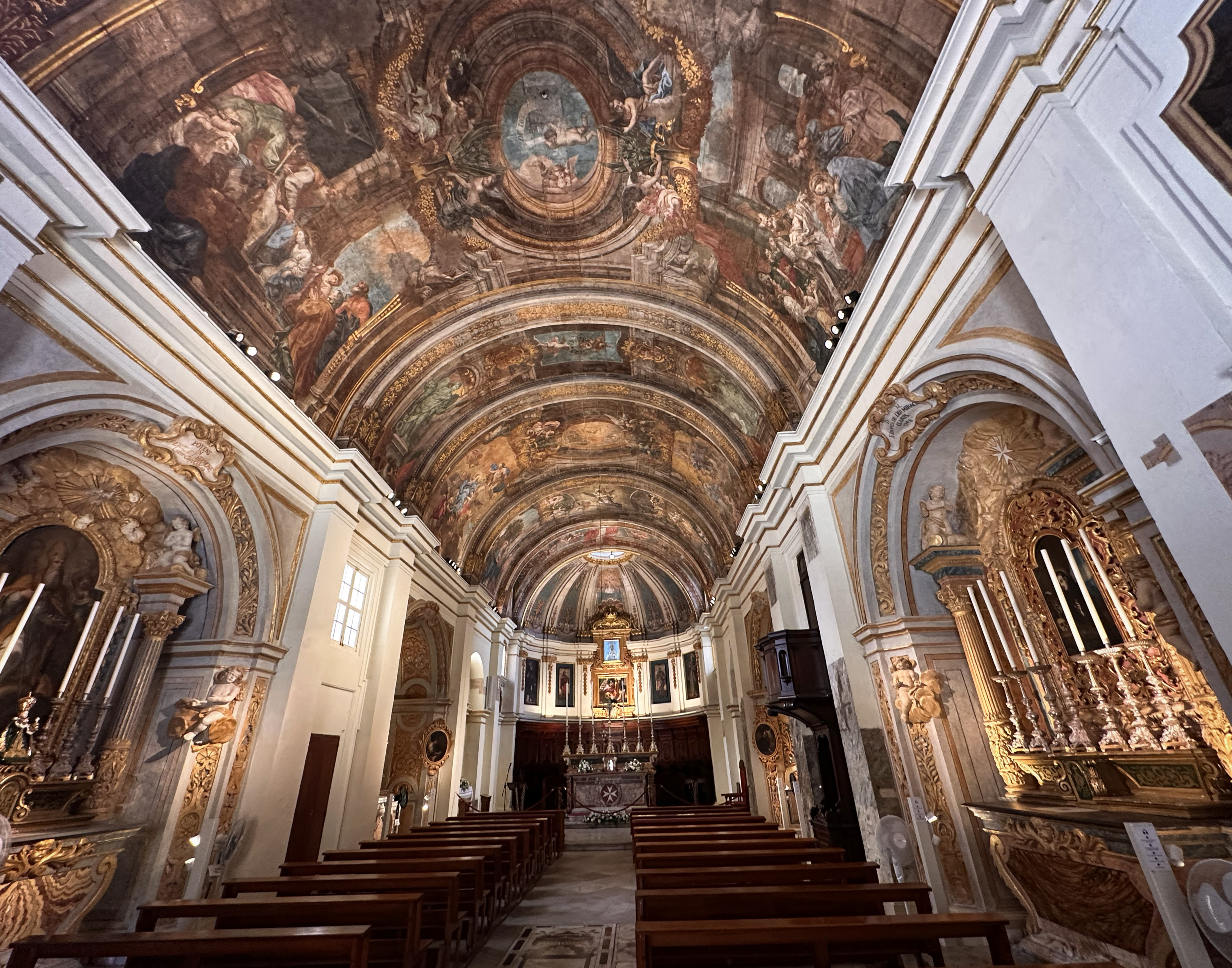
I had some fun taking time-lapses with no people in them, wandering the narrow alleys of Mdina. These are in the Instagram highlights. Some of the beautiful places in that city are below:
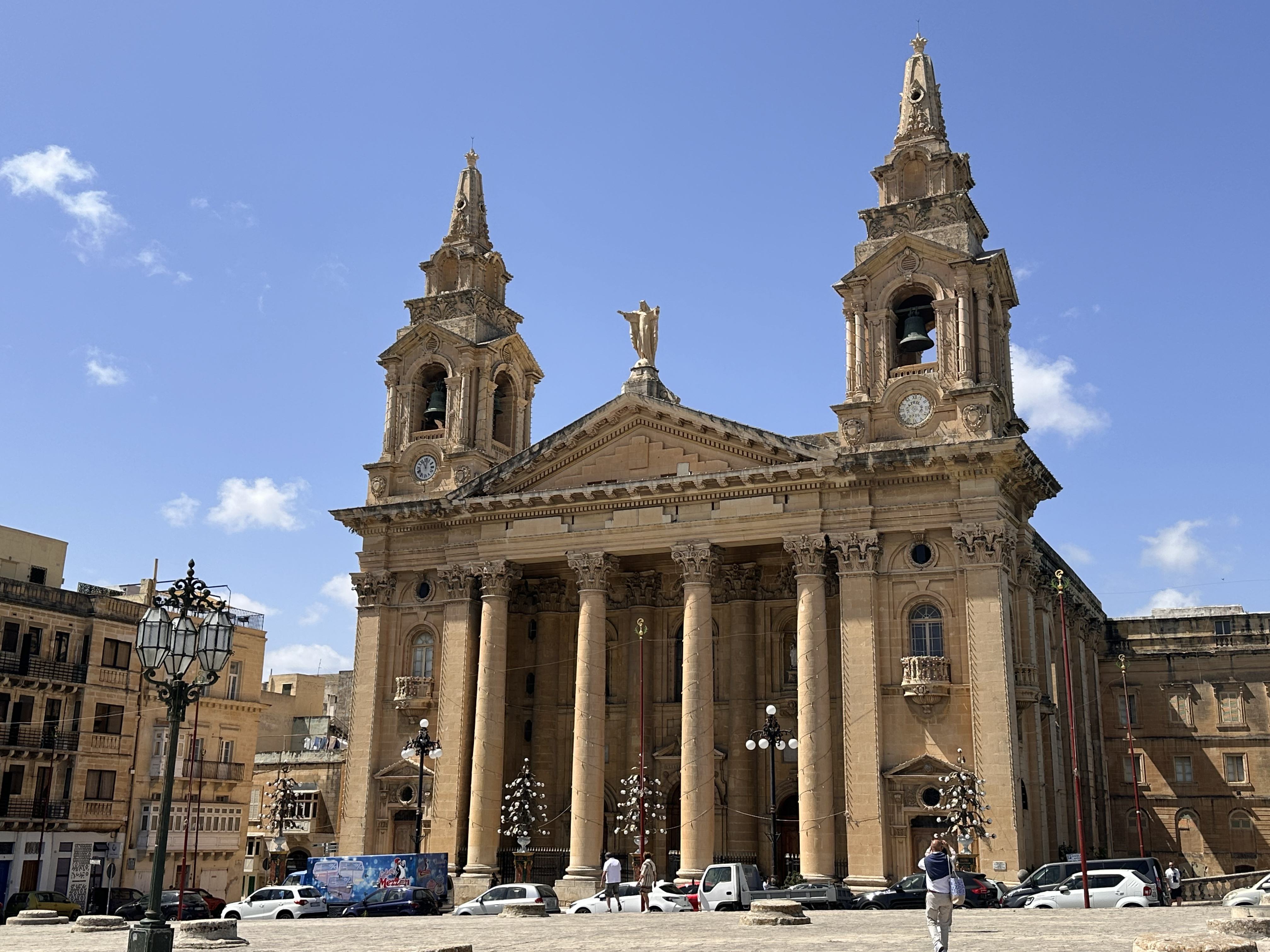
St. Paul’s Cathedral dates back to the 1100s, but after an earthquake destroyed it in 1693, it was rebuilt in its current, much different, Baroque style. There are two clocks on the face of it:
Legend has it that only one was ever set to the right time, so that the wrong one would confuse and ward off the devil. Other possible explanations include that 1) one is set to the local time and one to Rome (would be a bit odd, at least today, as they’re in the same time zone?), 2) one is based on tides (for fishermen) and one is the standard version, or 3) two helps with accuracy to have redundancy when one is being serviced. Just like the end of the Temple period, no one really knows for sure! The two-clock thing can be seen across many churches in Malta, not just this one.
At around 9am, I headed back to my car. I decided to stop at for some breakfast before continuing to the camera repair shop. If you end up with camera mishaps and need to go there, just know parking is a bit tricky! Once inside, David tried using a filter wrench to remove the circular polarizer, but quickly determined that it was stuck. I felt a bit better about my failed attempts to remove it (including putting it in the fridge for 10 minutes, to the amusement of my Airbnb host). She’d warned me that Malta runs on island time, so to not be surprised if a repair would take weeks. David said he’d need to keep it there to repair it, so when I cautiously asked how long, I was surprised when he said it could be ready by 3pm.
10 minutes down the road was Valletta, so I figured I’d make Monday a city day and Valletta the next stop.
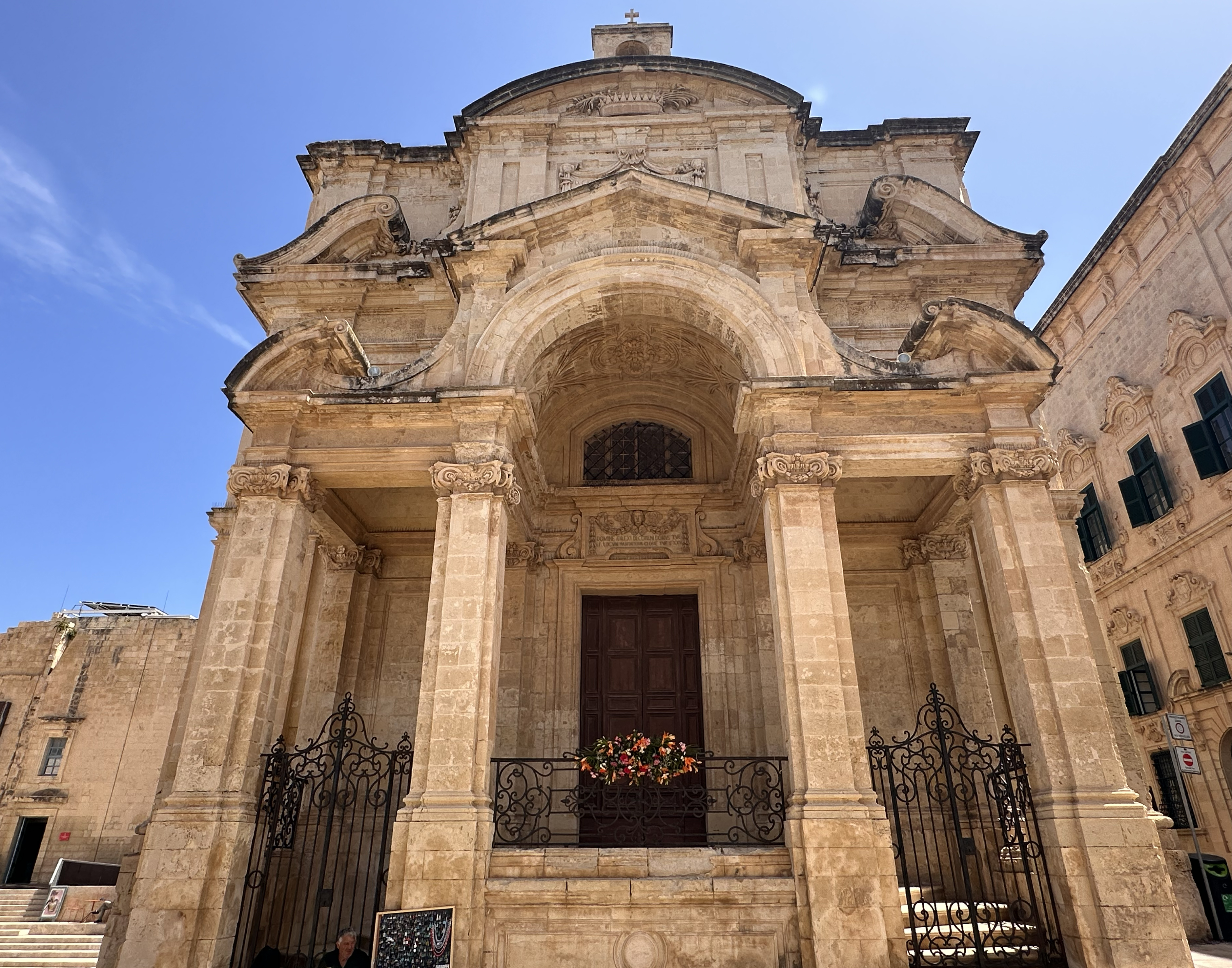
I parked at for 4 euros (it was the most straightforward, but Malta does have many free lots in many parts of the island). Right across from it was already a point of interest, Knisja ta ‘San Publiju (Church of St. Publius). It’s a neoclassical church that was built between 1733 and 1768.
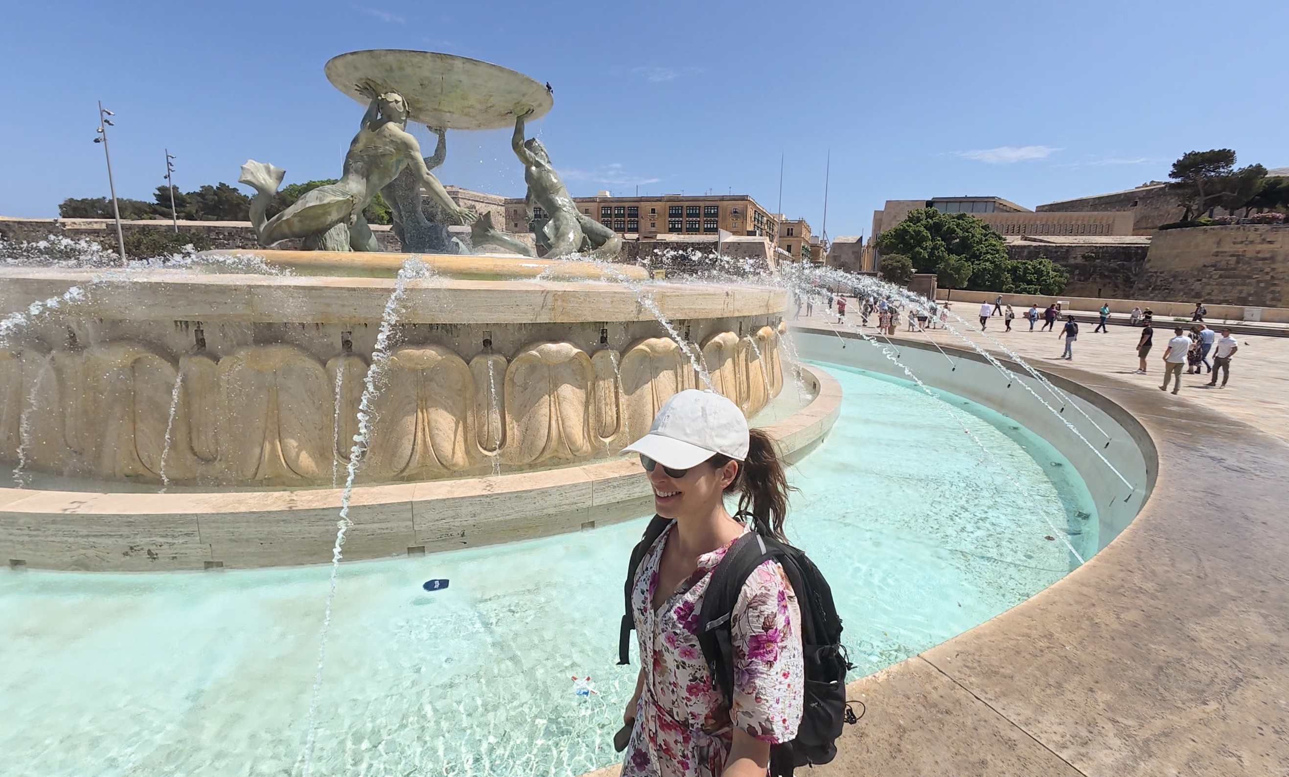
From there, I walked a few minutes down a nice path (the Ġnien tal-Maglio or Maglio Gardens, and “The Mall”) to the entrance to Valletta, with the large Tritons’ Fountain out in front. It’s been around since the 1950s and depicts three bronze Tritons (sea gods).
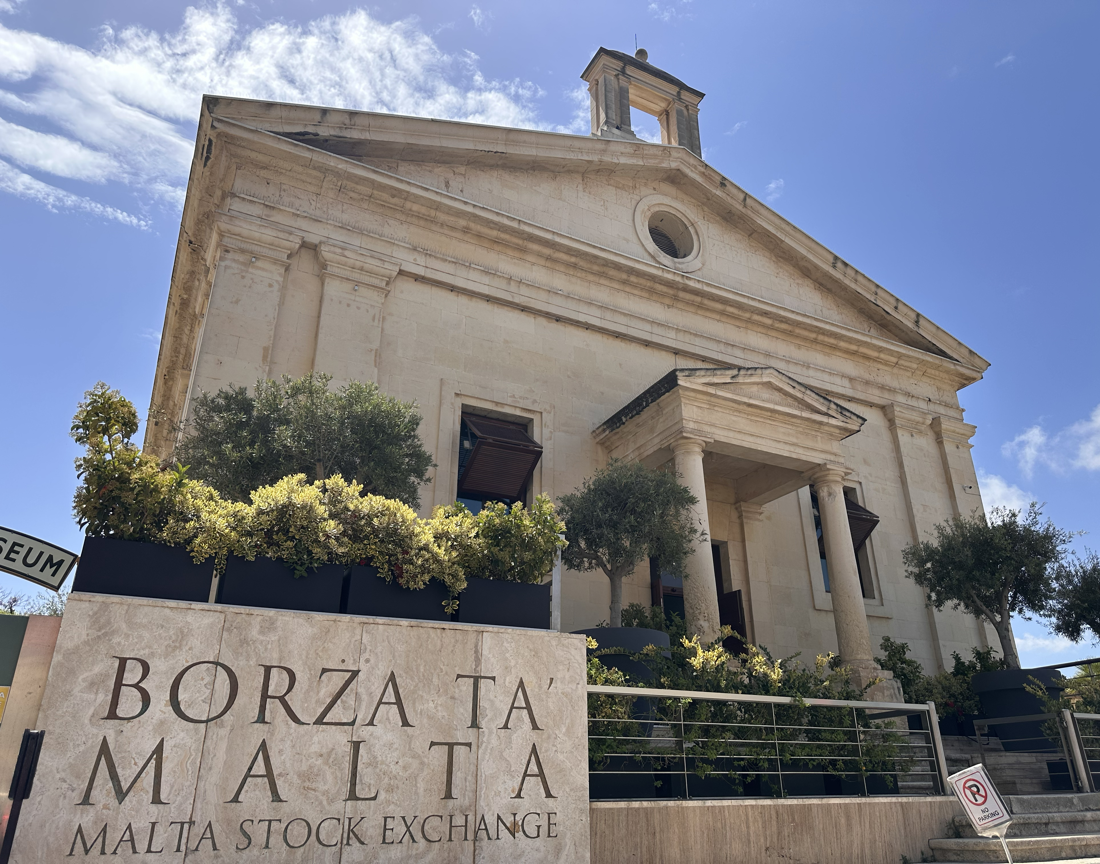
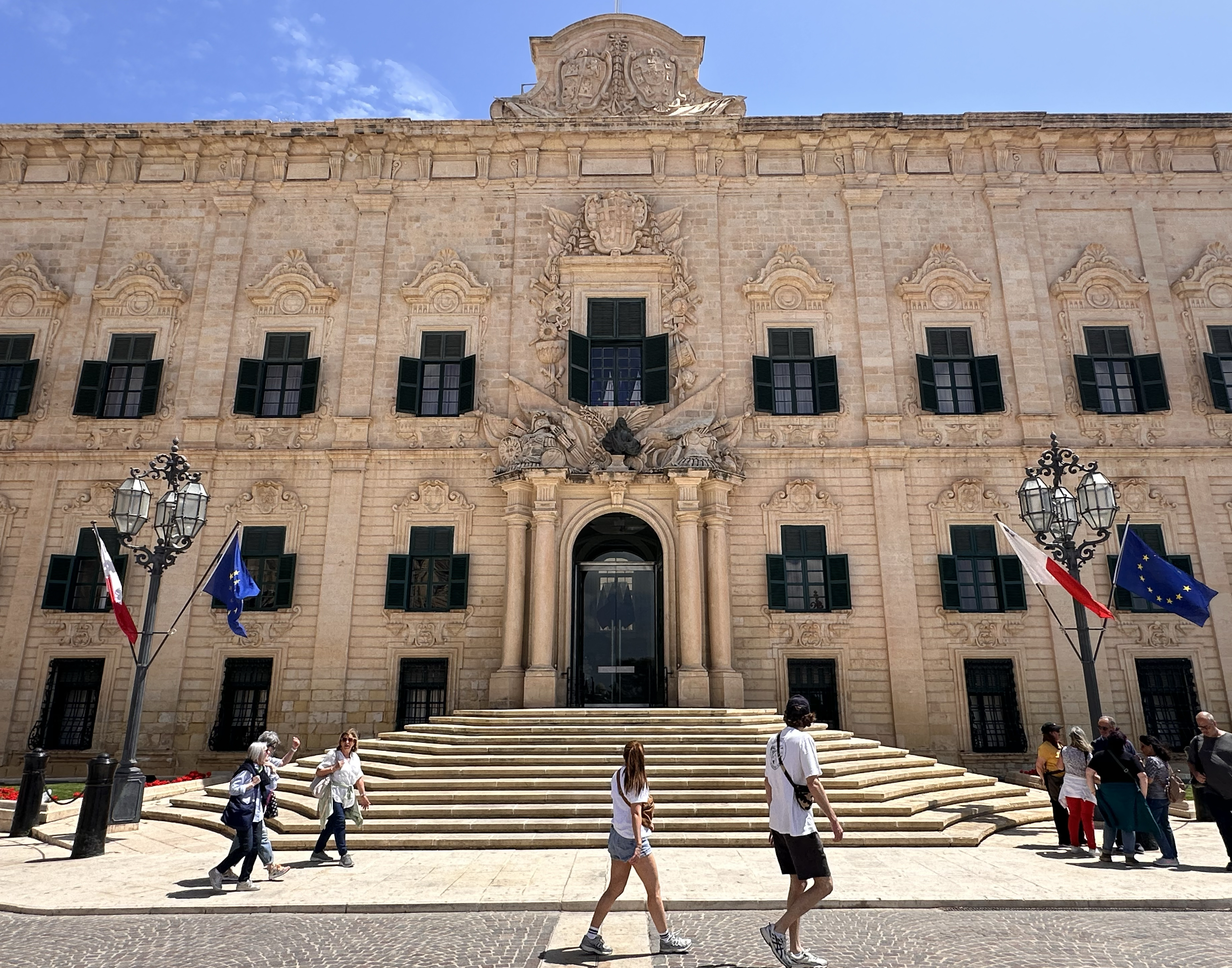
I followed the crowds across a drawbridge inside the fort walls to Valletta. This City Gate has been rebuilt many times, most recently in 2014. I took myself on a walking tour of some of the main sites, including the Parliament building, stock exchange, historic churches, monuments, and viewpoints. Instagram has more of a video tour of this, so this post will just include a few snapshots along the way. I even included an Avengers-style intro-the-characters Story, so look out for that one (:
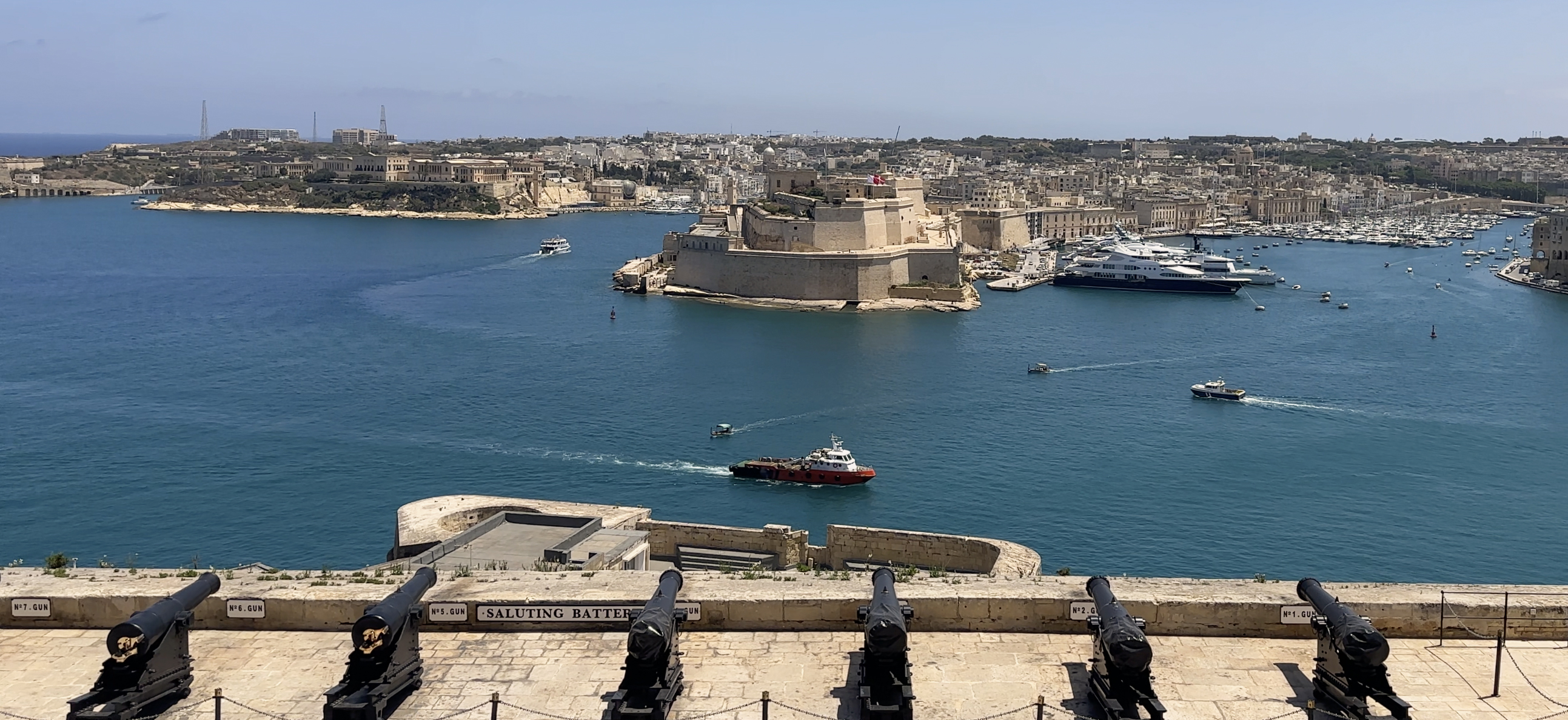
My walk then led me to the Saluting Battery, which had the largest crowds I’d seen in Malta thus far. There were people packed like sardines along the edge. What were they looking at, I wondered? Nothing was happening. Maybe I should have asked someone, but I went to find a bathroom instead. It was around 11:57 at that point. I popped out and found a seat along the side (the balcony was L-shaped) – why was no one here? There were sea views too!
I thought I remembered hearing a loud bang at around 12pm, but I went back to check my photo timestamps, and I’d taken 2 videos at exactly 12pm. Neither caught any notable sound. I didn’t think much of it at the time and headed off to find some lunch. I went to Elephant Shoe, as it had great reviews. They lost my order ticket and it took ages even once they realized that to get food – I probably spent almost an hour there for a quick order of arepas and a smoothie. The arepas were not great. If you go, there were plenty of other breakfast options that looked good, but maybe avoid the Latin food attempts. (:
It wasn’t until later that I realized the loud bang was the first of the only-twice-daily firing of the cannons. …Oops!
The next part of Valletta I wanted to see was on the tip, Fort St. Elmo. I took the lift down to sea level for a euro to save time, as I’d received the “your camera’s ready!” text during lunch, then walked along the coastal path to the tip. The views were beautiful the whole way!
I purchased entry tickets to the National War Museum, which is necessary to really see any of the fort. I definitely didn’t spend enough time there and the fee was 10 euros, so I’d only really recommend it if you have a bit more time to wander around the exhibits. I was there for maybe 30-45 minutes on a power walk.
After that, I headed up the main thoroughfare through Valletta, back across the drawbridge and to my car. I picked up the camera, grabbed some food from the nearby Lidl, and headed back to the Airbnb for some work calls. The Airbnb wasn’t too far of a drive from the Dingli Cliffs, so I decided to try the high point for sunset.
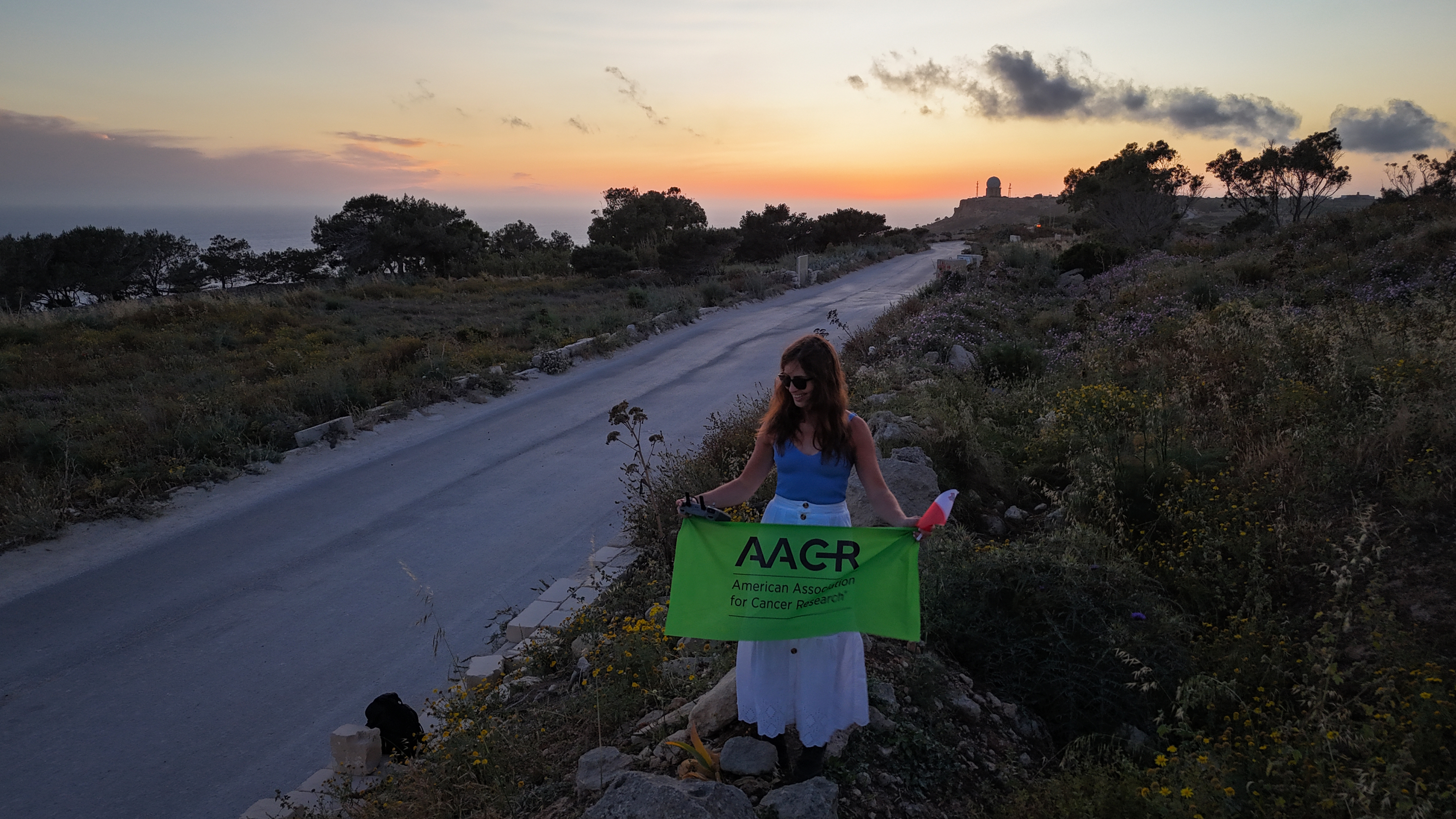
THE HIGH POINT
I probably headed out later than I should have, as I’d heard this high point could be tricky to find. Tricky is an understatement! There are 2 possible “high points”, one near a radio tower, and one in a quarry. I opted for the radio tower side first, as there was easy parking. I’d seen several photos taken from that point that seemed to involve a stack of cement blocks, but there was nothing of the sort over there. Following the recommendation of a fellow Crown of Europer, I downloaded an app to check my altitude. I couldn’t get anything above 250m along there, and the high point was meant to be 253m. I headed back toward the quarry and pulled over where the road seemed to crest. Only 240m…looks are deceiving. It seemed like the next rolling hill might go up again…so I kept walking. Sure enough, 248m. 250m. Close, but I couldn’t see anything matching photos I’d seen. I decided to focus on the altitude app. I walked to what was clearly the highest point of the road, then looked to my left. There was a way to climb up into the rocks/bushes on the side of the road, maybe even a slight path? I hopped up there. 252.67m!
The sun was getting really close to the horizon, and the sun would be setting in 15 minutes. I’d brought my camera but not my drone, and there was really nowhere to place a tripod up there. I walked as fast as possible back to my car 10 minutes away (still can’t run with the ankle cartilage situation), then pulled over closer to that spot. Two minutes to go!! I grabbed the drone, launched it, and headed back up to the 252.67m spot with the AACR and Malta flags.
I still wasn’t convinced this was “it”, but I took the photos anyway, hovering the drone, then flew it around a bit to get some of the scenery. The moon started to rise, large and golden over the horizon. I sadly did not have a telephoto lens. I headed back to the Airbnb.
Later that evening, I inspected my drone footage, other photos tagging Ta’ Dmejrek on Instagram, and photos sent by fellow Crown of Europers. I determined that the ‘official’ spot that was found was the one within the roped-off quarry. I’d opted not to go in, as the Airbnb host had also mentioned thinking the high point was in a ‘closed quarry’. From the point I was standing, I couldn’t really see anything higher. I think the quarry is expanding, too, so it’s possible that the high point changes someday! As it was, the point I was standing in was pretty close to the site. It seemed to be just as high, too – off by 0.33m. The consensus is that it counts, as in places like Turkey and Cyprus (with closed-to-the-public military bases at the true ‘high point’), it’s about getting as close as legally possible.
More Exploring
The next morning, the plan was to head to some cool-looking sea caves along the southeast coast, as I’d found a kayak rental spot called SIPS at St. Thomas Bay. After telling Jelena my plans, she joked that I was exploring the whole island except where I was staying. She suggested another place that I’d bookmarked as a sunset spot (around Għajn Tuffieħa), but after checking the wind direction, she agreed that the original plan was best for kayaking. I headed down there, through the island traffic (there’s a lot in Malta, even in May), and arrived with a bladder ready to burst. I didn’t see any restrooms, so I walk-ran up to the kayak rental place and said something to the effect of “Hi, I want to rent a kayak, but I really need a restroom, please tell me there’s one nearby?” There was a restaurant (Zion), thankfully! On the way out, I noted that the menu looked pretty good, with many gluten-free options.
I headed back over and had one of the most interesting kayak rental experiences. No waiver to sign, no ID taken, not even any upfront payment collected. Just “here’s a kayak! How long will you be?” I said I wasn’t sure, maybe 2-3 hours, and asked if the sea caves were just around to the right. They said yes and sent me on my way. I didn’t put sunscreen on, figuring I’d find a spot out on the water to stop and do that. This would turn out to be a mistake, ironically during Skin Cancer Awareness Week (& Month!).
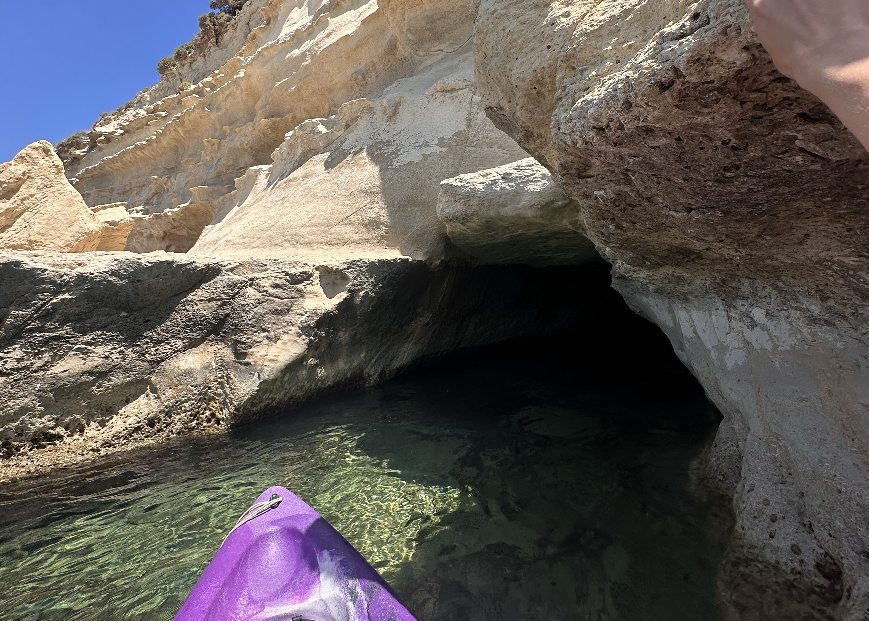
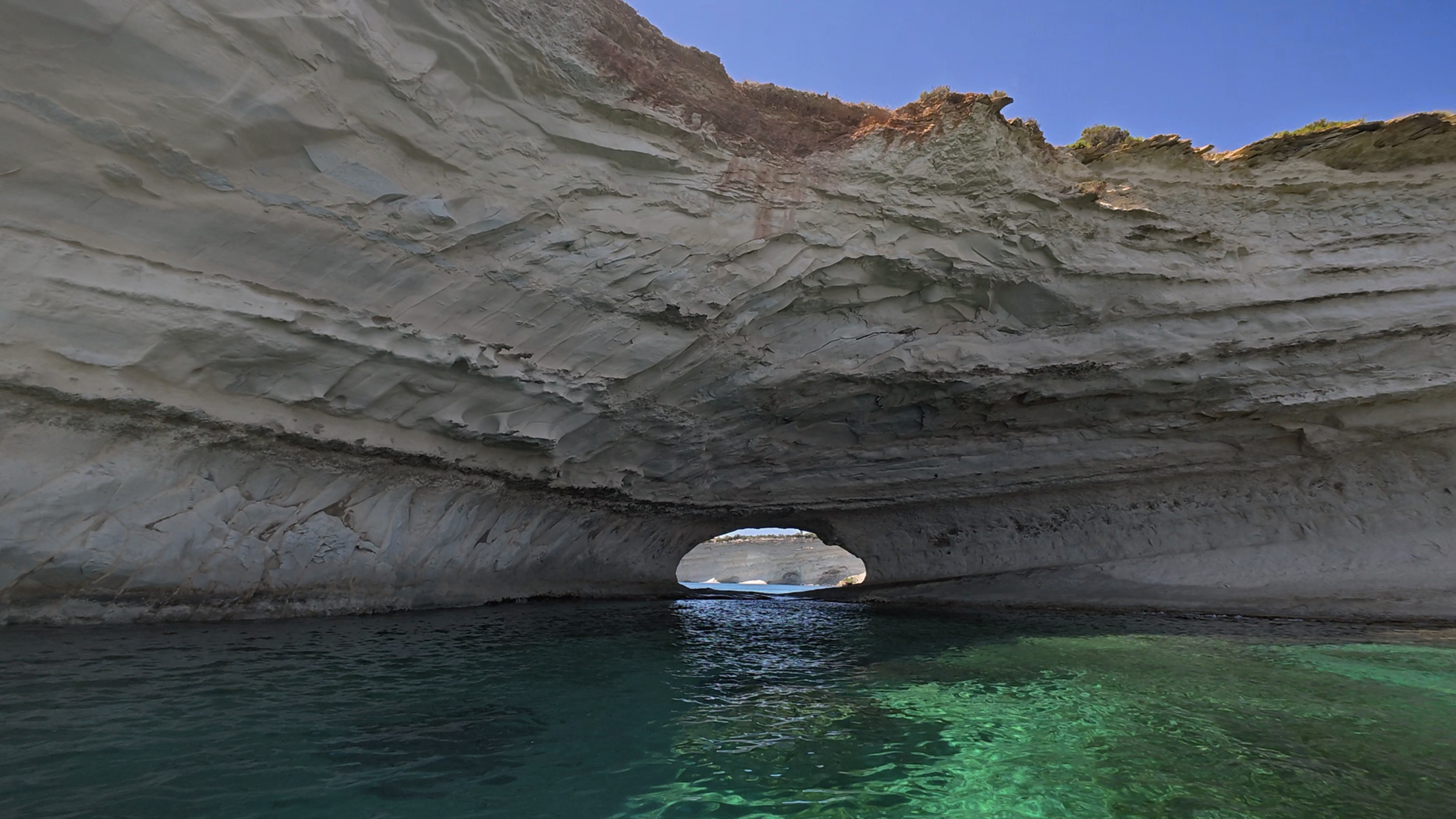
Within a couple of minutes, the water was so choppy that I couldn’t stop paddling for an hour straight. The first stop was through a cave, which was probably juuust calm enough to go through. The current was strong going in and exiting, so any attempts to stop in the tiny calm section in the middle would usually result in frantic paddling against the current when I inevitably drifted toward one side or the other. This was worth the upper body workout, though…just look at these views!
After that, there seemed to be a set of caves just around the corner, so I paddled toward them. As I got closer, it was clear that they 1) weren’t that interesting and 2) were way too rough to approach. I had phone signal, so I looked at my map and saw a cave I’d bookmarked around the next bend. It felt a bit far, but I’d made good progress and had only been paddling for 30 minutes. I continued.
At this point, the water got quite rough – maybe half a meter swells. I soon looked like I’d gone for a swim, not a paddle. I’d been told it was too cold for swimming…but the water didn’t feel too bad!
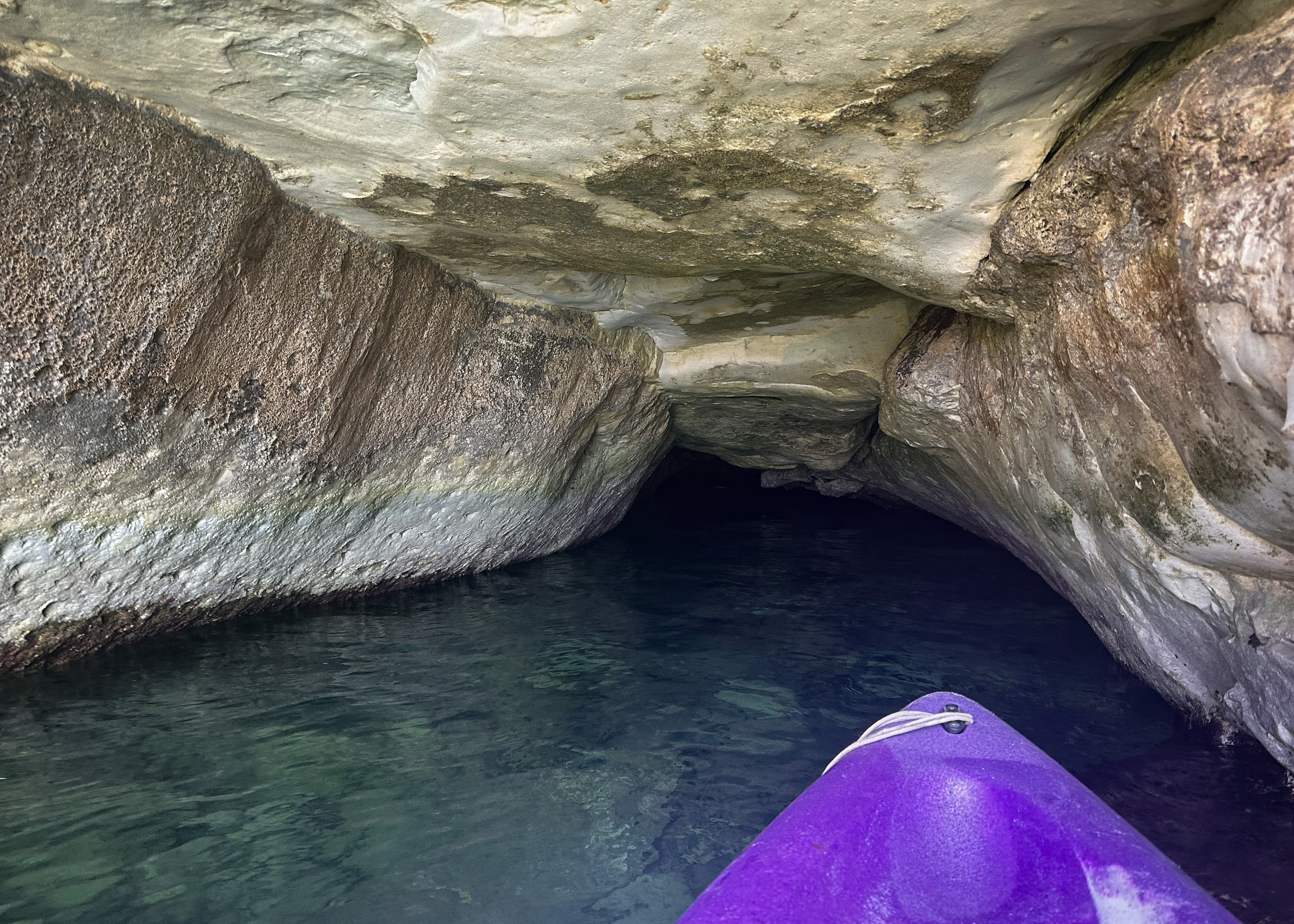
Finally, after almost an hour, the water became a bit calmer in that next sheltered cove. This was around the Ta’ Kalanka Sea Cave. I paddled up to where some were sunbathing and saw a small cave nearby.
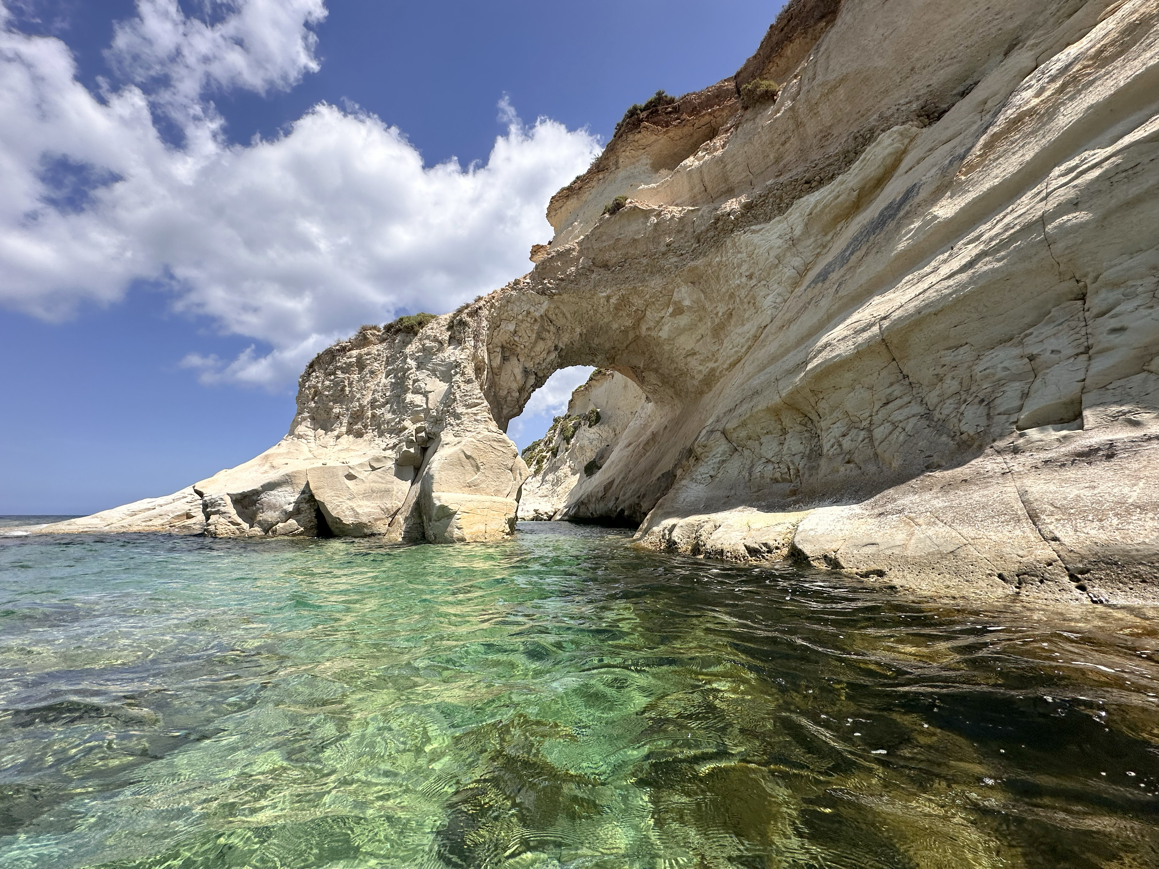
As I paddled out of it, I saw an arch across the way.
No one was there! As I got closer, it just looked more and more unbelievable. Still, no one in sight, just some sailboats moored a good distance away. The tides were perfect to beach the kayak and explore.
This is one of my favorite places in the world. I’ll be back someday, but I’m not sure I can recreate how perfect this day was. Maybe it was the conditions that kept people away, or maybe the water really was freezing, and I’d just assimilated too much into British life to notice. It really felt like it was at least 70 degrees Fahrenheit (21 Celsius), and I ended up going for a swim after walking around. There was a cave around the other side of it (pictured in that last photo above).
After maybe 30 minutes, a few small tour boats would pull up, hang around for a minute for guests to take photos, and speed off again. I was so grateful to have taken a kayak out. Those hello/goodbye boats didn’t seem too fun.
I spent about an hour there, then reluctantly started paddling back. I wasn’t sure if the currents would change substantially or conditions would worsen (plus, I’d told them 2-3 hours), otherwise I’d probably have stayed longer. I passed through that first cave/arch on the way back again, then pulled up on the boat ramp a few minutes past the 3-hour mark.
I had a late lunch at Zion Restaurant before driving to the nearest beach to the Airbnb. Jelena had said this was her favorite beach, and I could see why. It’s more of a sunrise spot, but it was still stunning as sunset approached. There are some stray cats there (well cared for ones, with beds and everything), and not too many people. There’s a beautiful rectangular tidal pool surrounded by salt flats.
I relaxed there for a bit, but then decided there was still time to drive 20 minutes to the sunset spot I’d bookmarked just across the island, on the west side: Għajn Tuffieħa. Parking was easy, and I joined the path along the ridge toward the Clay Cliffs. The great thing about this place is that there isn’t one perfect sunset view. There are many different views along it, so I ended up taking a circular path that would leave me on the beach after the sun went down. This is another one of my favorite places in the world, possibly. It felt like a mix of Iceland and Hawaii. Such unreal formations and views.
This was the last day of my trip, and it couldn’t have gone more perfectly (except maybe the sea kayak conditions, but maybe it’s what allowed for some solitude!). The next morning, I decided to add one last stop, back to Qawra Pool for sunrise.
The multiple bug bites on my face were worth it, and it was another stunning Maltese spot I had to myself:
I headed back to the Airbnb to pack up, then to the airport to return the car. I grabbed some food in the airport lounge, which has an outdoor terrace you can watch the planes from. Nice, sunny end to a nice, sunny island visit, complete with plenty of sunscreen and midday shade.
THANK YOU ❤
Thanks for reading my tenth Crown of Cureope blog post. At the time I stood on the top of Malta, we had raised $1,275 for the American Association for Cancer Research to fund lifesaving discoveries. This is more than halfway to this year’s goal, so thank you!!
Also, this is the first case of a trip coinciding directly, and intentionally, with a significant cancer awareness week/month. It was during Sun Awareness Week and Skin Cancer Awareness Month (May). Skin cancer is something that has affected many people in my family, and it’s the most common type of cancer globally. While it tends to have high survival rates, it’s important to catch it early. So, please, get your skin checked regularly, wear sun protection (it’s easier to prevent than keep cutting up your skin, where possible), and take the risk seriously. We’re having some crazy heat waves this summer, so it’s more important than ever!!
Map of Places to Visit in Malta:

Leave a comment